The History of Barnbow Part 6 Back to the Main Historical Society page
Back to the Barwicker Contents page
Part 1 of the article

The History of Barnbow


Part 6 BARNBOW FARMS IN THE MID-NINETEENTH CENTURY


from The Barwicker No.64
Dec. 2001


The entries for Barnbow in the 1861 census are, like their predecessors, distinct from those of the numerous small settlements nearby, such as Lazencroft and Shippen. In Barnbow Springs there were three households with a population of nine. Occupations were coalminer, coal dresser, engine tender, female servant, dressmaker and cordwainers' widow. Surnames of the heads of the households were Cawood, Tillotson and Thompson.

Under Barnbow, five large households were listed, with a total population of 32. Occupations were agricultural labourer, coal miners (6), dressmaker and female servant. Surnames were Lawton, Goodall, Hague, Scholes and Smith. The 1870 plan shows that these dwellings were in Barnbow Lane.

In Barnbow Carr there were two unoccupied houses and eight households, with population of 21. This included Joseph Richardson aged 45, a farmer of 32 acres, living with his wife and teenage son. At 'Spring Farm' we find Edward Furniss aged 46, a farmer of 250 acres employing two labourers. He lived with his wife, son and three daughters, two teenage male (farm) servants and one teenage female general servant. Other occupations in Barnbow Carr were fireman, roadmender, annuitant (female), tailor, coal miner and agricultural labourers (2). Other surnames were Stott, Goodall, Legat, Thompson 2), Stuart and Lawton. The number of households under the various sections for Barnbow was 17 with a total population of 71. Most of the adults were born locally. Many of the children were born in Barnbow.

A valuation book for the poor rate in the township of Barwick was drawn up by Richard Gouthwaite of Lumby and dated 11 February 1862. The copy preserved in Sheepscar was part of the Gascoigne collection and numerous notes have been added at a later date. The book lists all the properties and parcels of land in Barwick township. For each numbered item, the following information is given: the names of the owner and the tenant, a list of the buildings, the names of the parcels of land, the type of cultivation, the acreage, the estimated rental and the rateable value. Many of the field names do not appear to be of any great antiquity. The book contains a large scale plan, drawn in 1870, of all the land and property in the township and labelled with appropriate plot numbers.

It is possible to draw a picture of land ownership, tenancy and use in Barnbow at that time. The 1849 Ordnance Survey map has been modified to mark the field boundaries drawn on the 1870 plan to show the land worked by the two Barnbow farms. The modified map is shown below.


The details of the farm rented by Edward Furniss from the Gascoigne estate are shown opposite and marked on the map below. It was one of the largest farms in Barwick parish at that time. In 1839, a report of a vestry meeting showed that he then occupied property with a rateable value of 161 which entitled him to five votes at the meeting. In the 1841 census he is listed as 'farmer' with no more details. In 1851, he is described as a farmer of 180 acres employing two labourers.

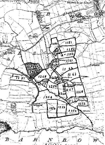
THE FARM OF EDWARD FURNISS OF BARNBOW
Plan No
Name of property
 
Cultivation
 
Acreage 
     
ac. 
r. 
p. 
1150   Great Bents and Top Garth   Arable   8. 0. 
1151  Little Bents and Wall Close   Arable   9.  2.  14 
1152   South Near and Little Wall Close  Arable  9.  0. 
1153   North Great Field   Grass  7.  3.  10 
1154   Croft  Grass  4.  1.  37 
1158   Road   -   0.  1.  14 
1159   Farmhouse (Carr Head), Barn, Stables, Cowhouses, Cart Shed, Yards and Orchard.   -   0.  2.  25 
1160  Grass Holme   Grass  4.  1. 
1161   South Great Field  Grass  8.  2.  23 
1162   North Slack Burn & part of Marl Pit Field   Arable   14.  0. 
1163  South Slack Burn & part of Marl Pit Field  Arable   12.  3.  21 
1164   Occupation Lane  -   1.  0.   8
1165   Old Quarry   1.  0.  11 
1166  Lane  0.  1.  12 
1167  Quarry Field and Brown Close   Arable  11.  0.  15 
1168   Limekiln Field and Clayhole Close   Arable  15.  3.  11 
1168a  Old Quarry  0.  0.  15 
212  Wood Close, Shoulder of Mutton and part of Broadbent Close   Grass  12.  3.  36 
1252   Crabb Flat and part of House Close   Arable  10.  0.  33 
1253   Cow Close and part of House Close   Arable   11.  3.   12 
1254  Low Pasture and Low Field   Grass  11.  1. 
1256   Long Close, Two Acres and Low Field  Grass  34.  3.  23 
1257  Barnbow Carr   Grass  8.  2.  37 
1258   Willow Garth  Willows   0.  0.  14 
1259   Ash Hills   Arable   10.  2.   4  
1260  Well Field and Little Ash Hill   Arable   9.  1.   5  
1261  Croft   Grass  2.  3. 
1262  Farmhouse, barn, stables, cowhouse, cart shed, yards and garden   -   0.  2.  28 
1263   Ashhole Close   Arable   6.  3. 
1268   Carr Close   Arable   10.  3.  29 
1297   Top Pasture and Carr Close   Arable   10.  0. 
  Total  £249.2.11d.       
  Total Estimated Rental  £273.7s.6d.       
  Rateable Value   £248.9s.6d.       


The 1862 valuation book and plan show that the 'Spring Farm' of the 1861 census was in fact the 'Barnbow House' shown on the Ordnance Survey map and now called 'Upper Barnbow Farm'. He was also the tenant of Carr Head Farm, which he must have sub-let to one of the families in the 1861 census.

The plan reveals that Edward Furniss's farm was a very compact land holding in the northern part of Barnbow. The fields are numbered to indicate them on the map. There were about 154 acres of arable land and about 82 acres of grass. Some field boundaries had been changed from the 1849 Ordnance Survey map. The names of the fields show that some had been created by combining two parcels and other fields had been split and the parts added to other units. The acreages show clearly that the aim was to create a farm with arable fields of about 10 acres. This would no doubt have been done on the instructions of or at least with the approval of the landowner.

The purpose of these changes would be to produce what was considered the best model for farming at that time. Earlier in the century, the rectors of Barwick laid down farming practices for the tenants of their farms in Barwick. (see 'The Barwicker' No.7). An important condition was that about one third of the land should be permanent grassland, as is the case at Edward Furniss's farm, to enable the fertility of the land to be maintained.

The other Barnbow farmer in the 1861 census was Joseph Richardson, with 32 acres. He was not a tenant in 1851. His land holdings shown in the 1862 book are listed below and some are shown on the map by cross hatching but the rest are too small to be identified on the map Edward Furniss had land rented from one landlord producing a compact farm within the confines of Barnbow. Joseph's Richardson's farm however was a collection of pieces of land rented from different landlords and scattered so that some were not in Barnbow. The land shows few of the changes in plot size, etc. which were thought to be needed to produce an efficient farm of the time.

The valuation book and plan enable us to locate some of the other dwellings in Barnbow at this time. On the western side of Barnbow Lane just north of the Cock Beck, there were two cottages occupied by Thomas Goodall and Stephen Smith. There is no sign of them today as buildings for the Shell Filling Factory (see 'The Barwicker' No.47. page 46) were erected on the site.

THE FARM OF JOSEPH RICHARDSON
LAND AND PROPERTY IN BARNBOW
RENTED FROM THE RECTOR OF BARWICK   
1269  Barnbow Close   Grass  0.  1.  16 
1270  Barnbow Close   Grass   5.  0.  26 
1272  Barnbow Close  Arable  5.  2.  10 
RENTED FROM THE DEVISEES OF WILLIAM GLOVER 
1273 Low Close   Grass  3.  2. 
RENTED FROM JOHN DALBY (OF BARNBOW) 
1264   Stables and Orchard   Grass  1.  2. 
RENTED FROM JOHN THOMPSON (OF BARNBOW) 
1266   Garden     0.  0.  10 
1267  Common Close  Grass  1.  3.  18 
1277  Orchard and garden    0.  1.  10 
1278   House, barn, stables, cowhouse and garden     0.  0.  32 
RENTED FROM SAMUEL THOMSON (OF BARNBOW) 
1280  Cottage    0.  0. 


In addition, Joseph Richardson rented in the Carr Field area of Barwick, one close from the Rector and two from John Wilson, a total of about 16 acres. This brought his total holding in Barnbow and Barwick to 33ac.0r.25p, with an estimated rental of £51.13s.7d and a rateable value of £47.1s.7d.

To the western side of Barnbow Lane north of the Hall site, there were three cottages occupied by Major Hague, William Scholes and Charles Smith. With the two above, they comprise the five dwellings listed under Barnbow in the 1861 census. They are all let by the Gascoigne estate. The site is on a small piece of grassland with a few ancient trees, which may have acted as a windbreak for the cottages. A number of bricks and large pieces of stone can be seen at the base of the trees, some with plaster indicating that they had been used for building. There are pencilled notes in the valuation book under the cottages of Hague, Scholes and Charles Smith stating that they had been demolished but we do not know when these notes were made.

On the Old Hall site on the west side of Barnbow Lane there were two cottages, occupied by George Wigglesworth and William Warrington. They were sub-let to the above by Lazencroft Farm, which was rented from the Gascoigne estate. On the site there are many small pieces of brick and stone. These cottages stood until the early part of the 20th.century. There is no evidence on the plan of Bog House or any dwellings near the junction of Bog Lane and Barnbow Lane.

The plan shows that there were four cottages rented by George Newby, William Stott, John Goodall and Joseph Richardson on Barnbow Lane close to its junction with Taylor Lane. In addition, at Carr Head, there were two cottages (plus one unoccupied) tenanted by James Armitage and James Thompson. None of these seven cottages was part of the Gascoigne estate but belonged to a variety of small local landlords.

At Barnbow Springs, the three dwellings listed in the 1861 census are included in the valuation book as part of the Gascoigne estate. There is a cottage, barn, buildings and land, with a small arable plot and two grass plots of about one acre each were rented by Thomas Cawood. There is also a cottage, barn, cowhouse and garden, with two grass plots of about 4 acres each rented by William Tillotson. Also there, we find a cottage, stable, cowhouse, garden and a close of about 4 acres described as arable and grass, occupied by Elizabeth Thompson. The precise location of these properties and land is not shown on the plan.

South of Barnbow Springs and the Cock Beck is the area labelled Barnbow Common on the 1849 Ordnance Survey map. The valuation book and plan show four arable closes here called Far Shippen Field and Near Shippen Field (farmed from Shippen), and Far Ley Field and Ley Field and part of Peat Mires (farmed from Stank House). These closes also appear on the 1772 Flintoff map. Why the area acquired the name 'Common' we do not know.

All the woodland in the Gascoigne estate is said to be 'in hand' and includes:
  • 1211 Springs Wood 7a.0r.9p
  • 1326 Barnbow Hall Wood 10a.1r.38p


  • The land to the west of Barnbow Lane was farmed from Lazencroft and that to the south of the Cock Beck from Lazencroft, Shippen, Stank House and Barrowby Grange (called Bradbury in the valuation book). The policy of the Gascoignes was clear, to create five large efficient farms in the southern part of Barwick parish,including that of Edward Furniss in Barnbow.


    ARTHUR BANTOFT


    Back to the top
    Back to the Main Historical Society page
    Back to the Barwicker Contents page
    Part 5 of the article