Ralph Thoresby's Journey to Barwick

Ralph Thoresby's Journey to Barwick - 1702


from The Barwicker No.51
Sept. 1998

Back to the Main Historical Society page
Back to the Barwicker Contents page

The diary for the years 1677-1724 of Ralph Thoresby FRS, eminent antiquarian and author of 'The Topography of Leeds', was published from the original manuscripts by the Rev. Joseph Hunter FSA and contains an account of a journey to Barwick on 29 May 1702 at the age of 43. The following is an edited version of his notes.

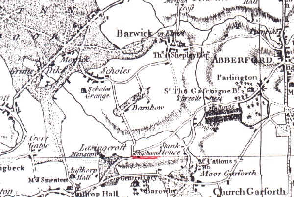
"29 May. Took the measuring-wheel, and having surveyed to the extent of the parish at Wikebridge, continued it by Secroft, (leaving Penwell Dale on the right hand) and Grimesdike, or Morrickfur, to Winmoor, thence by Scoles Outwood (which an old man told me himself can remember a thick wood, though now there is not a tree upon it), over Cock-beck; thence over Rakehill, which, whether it have any historical relation to the memorable battle I cannot tell; crossed the yet little beck of the Cock again. thence over the Car and up Windlehill, to Berwick, seven miles by measure, (from Leeds church to that at Berwick) though but five by computation.
Was disappointed of my expectations in the church, there being no monuments for the ancient family of the Gascoignes or Ellis's, save only fragments of their arms, etc. in the painted glass, but most of the windows defaced etc. But was mightily pleased with a very remarkable mount, which I surveyed strictly, (vide the dimensions elsewhere), which is to this day called the Hall-tower-hill, which confirms my former notion, that when the Saxon kings had their regional centre at Leeds, this was a manor grange farm, country seat, appendant thereonto.
Besides, there is a universal tradition of a king's residence there, etc. The old parsonage house is demolished and now re-edifying by Mr Tankard, the Duke of Leed's chaplain, but I found little remarkable there, save the King's arms in painted glass, which yet must be after Edward III, because the flowers-de-lis are limited to three: King Henry V, first stinted them to three. Returned by Scoles over another part of Winmoor, etc. Observed the toll-gatherers booth, where the agents of Sir Thomas Gascoigne are ready to receive toll of the carriages, which, at a penny a pair of wheels, amounts to a considerable sum."

The landscape viewed by Thoresby nearly 300 years ago would bear little resemblance to that of today. The Enclosure Award of 1804 made the most significant impact on the rural scene, when open fields and commons were transformed into a regular squared field pattern bordered by straightened hedge-lined roads and lanes.


Thomas Jeffrey's map (above) of 1770 (he was Geographer to George III) gives a representation of the countryside terrain in the 18th. century, showing the large expanse of Winmoor crossed by trackways, including the precursor of the now heavily trafficked Leeds-York road. Leaving Wikebridge (Wike Beck near Killingbeck), Thoresby's route took him through Seacroft and by Penwell Dale ('pen' - a fold), a small holding that was located south of York Road, and alongside the former Stanks Lane, all now within the Swarcliffe estate. Several streets within the housing development have names pre-fixed with Penwell - Penwell Garth, Dene and Lawn.


Penwell Farm off Stanks Lane. (Known as Betty Barkers) (1905)


Further along his route passed Grimes Dike, in a shallow valley, crossing the beck of that name (known also as Hurst Beck); downstream the watercourse becomes the Cock Beck. Grimes Dike was the site of fish ponds belonging to Sir Thomas Gascoigne, lord of the manor.

Morwick (dairy farm on the moor) shown on the map in a clearing, can still be identified, but Scoles Outwood is lost - treeless apparently in Thoresby's time.

An entry in the Wakefield General Sessions held 10 June 1638 records -

"A penalty of £100 is laid upon Thomas Gascoigne, bart. that he threw down the dam near the King's high-way in a place called Scoles Wood erected to the great damage and hurt of all the King's lieges, before the next General Sessions. (At Wakefield 15 Jan 1639 upon certificate remaining in Court, the penalty is exonerated)."


Thoresby refers to going over Rakehill and twice crossing the Cock Beck but this was more likely the Rake Beck which does re-cross Rakehill Lane between Scholes and Barwick.

Thoresby records his impression of Barwick Church and Hall Tower Hill earthworks and refers to the new building of the parsonage by Mr. 'Tankard'. The Rev. John Tancred MA was Rector of Barwick from 1695 - 1703.

Returning to Leeds via an alternative route over Winmoor, Thoresby observed Sir Thomas Gascoigne's 'Penny Toll' booth (at the junction of York Road and Coal Road). This was not a Turnpike Toll but a duty or levy demanded by the lord of the manor under an ancient custom known as 'chiminadge' -
"Which is a penny for one wain, cart or pair of wheels which shall pass over ye moor which custom is to be paid by strangers not being commoners thereon".


Thoresby measures the distance travelled from Leeds Church to that at Barwick as seven miles. This reduced by computation to five miles, a significant adjustment. Jeffrey's map shows a seven-mile-stone on York Road near Flying Horse Farm (formerly called Half Way House being seven miles from Leeds and seven miles to Tadcaster).

In 1720 Turnpike Trusts were required to measure and signpost their roads. It would be interesting to have had Ralph Thoresby's learned observations on a milestone (opposite the Fox and Grapes on York Road) being classified as a listed building (see 'The Barwicker' No.40).

TONY COX


Back to the Main Historical Society page
Back to the Barwicker Contents page