History of Potterton 3
The History Of Potterton.
PART 3 THE DENISON YEARS
from The Barwicker No. 38
June 1995
Back to the Main Historical Society page
Back to the Barwicker Contents page
By the time of Robert Fretwell's death in 1770, we find that his land had been sold to Edwin Lascelles and his house and grounds to Robert Denison.
Something can be discovered about the lives of the inhabitants of Potterton at this time from the baptisms and burials records of Barwick parish. (The marriage records specify only the parish and not the hamlets within the parish.) During the decade 1770-79 we find in Potterton five farmers: Thomas Whitead, Robert Bickerdike, John Wood, Mark Lofthouse and George Watson, five labourers: Thomas Hanson, Benjamin Bramley, Samuel Harrison, Henry Forster and William Lee, three shoemakers: John Cullingworth, William Richardson and Luke Richardson, a mason (Edward Day), a gardener (William Sherriff), a tailor (Thomas Shillitoe), a thatcher (Thomas Thornton), Thomas Poulter (no given occupation) and Thomas Harrison, who is rather confusedly described as a 'spinster'.
In the early 1770s, Edwin Lascelles of Harewood started to dispose of his Potterton property. At the end of 1772, the lease of the tan-yard and related property was advertised on his behalf as shown by the following extract from the Leeds Intelligencer dated 22 December of that year:
"To be let, situate at Potterton near Aberford, a large and convenient Tanyard, remarkable for tanning of good Bends, with a Tan-house, Bark Chamber, and Two Cottages near to it, with a House, Barn and other outbuildings and 34 acres. Water will be warranted to the Tanyard. Enquiries to Mr Popplewell of Harewood, (the steward of Edwin Lascelles for many years). Thomas Thornton of Potterton will show the Premises."
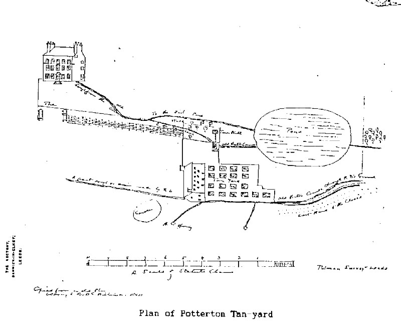
We do not know who or if anyone rented the tan yard at this time. The output of a tan-yard was governed by the number of pits available. This could vary from 5 or 6 to as many as 40 in number. In the papers deposited with the Thoresby Society, Rector Colman includes a rough sketch of the Potterton tan-yard, which was copied in November 1903 from an old plan belonging to Rev. B.G.Wilkinson, the owner of the Potterton estate at that time. This was drawn to a scale of two statute chains to one inch. The plan probably dates from some time after Robert Denison bought the land in 1774.
Colman's sketch of the tan-yard is reproduced below and shows 18 pits laid out in front of the tan house. Water supply was led into the yard and adjoining fish pond from the main hall cellar, from land drains and nearby natural springs. The drawing shows Potterton Lodge, the west wing of the present Potterton Hall. The rather naively drawn tan house is shown as a substantial building of which no trace now remains. The neatly built wall with its elaborate gate posts represents the western limits of the grounds and runs much closer to the house than the present boundary and gates.
In 1774, Robert Denison, who already owned the hall and adjacent grounds, became the tenant of the Lascelles land in Potterton at an annual rent of Ł115. This was later confirmed by a deed, a copy of which is in the papers deposited by Rev Colman in the Thoresby Society archives, stating that on 21 August 1778, Robert Denison leased the Lascelles land at Potterton for 96 years from 28 November, 1778.
A copy of a plan of the land covered by the lease was also deposited by Rev Colman but he does not appear to have used the plan in his book. It shows the scattered nature of the holdings and it gives information about the farming methods used in Potterton at the time. It also shows the property already owned by Robert Denison, the buyer, including Potterton Lodge and adjacent grounds. Like most such surveys the plan shows the land to be leased and little else.
The area of each marked parcel, in acres, roods and perches, is given. Some plots of land are long and narrow and the number of ploughing strips or lands is given. e.g 5L. Some of the plots have been enclosed from the open fields and in some cases the names of the closes produced are given e.g. Great Close. Also included in both kinds of plot are the initial letters of the names of the tenants at that time, viz. S for Scholefield, H for Harrison, T for Thornton and B for Bell, these tenants remaining unchanged from the time before Denison took over the land. In accordance with the custom of the time, the names of the occupiers of the land immediately adjoining the marked plots are shown.
Colman's notes contains the details of the holdings of the four tenants. It also shows that Robert Dension had bought the tanyard.
| acres | rods | perch |
| Scholefield | 65. | 1. | 36
|
| Harrison | 41. | 0. | 34 |
| Thornton | 35. | 0. | 38 |
| Bell | 0. | 0. | 30 |
| Total | 142. | 0. | 18 |
| Tan House and Yard | 0. | 1. | 5 |
The plan shows that, in this period, the open field system was still operating but its scope had been considerably reduced by enclosures created by individual land owners. All three aspects of open field farming are still evident. The names of the open fields given in previous sources (Raw Field, Beck Field, North Field and New Field) are not mentioned but the plot on the map marked Upper Field might be the remains of another open field. The long narrow areas marked on the plan are typical of the ploughing strips of open field cultivation.
| Plan of land leased by Edwin Lascelles to Robert Denison in 1778 |
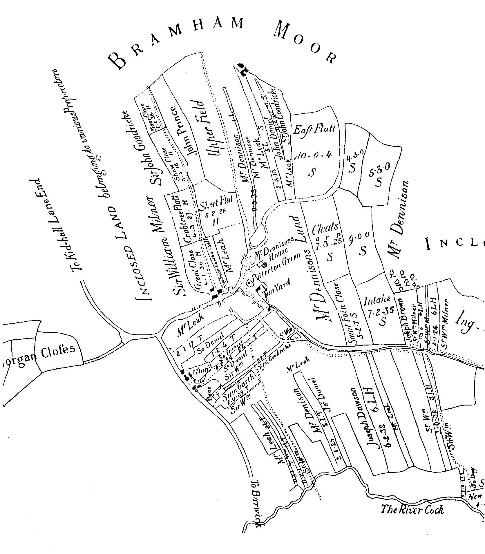 |
We do not know the extent of this method of land use and division, but we must assume that where strips are shown they exist alongside more, perhaps many more, strips belonging to other owners. The second components of the open field system are the ings or river meadows which are used for the production of hay. Thirdly, the common or waste, shown as 'Bramham Moor' on the plan, was used for common grazing and the collection of fuel.
The names of the 'closes' can tell us something about their size (Great Close, Short Flat), their geography (Moor Close, East Close) or their history (New Close, Intake, a plot taken in from the common). Who were Spelman and 'Sam' who gave their names to closes shown on the map? 'Morgan' was probably the name of a local landowner or farmer and not an ancient British king, the romantic view of more imaginative historians. But what is the origin of the name 'Cleats'? 'Saint Foin Close' must arise from 'sainfoin', a valuable leguminous plant used for hay or pasture, especially for sheep. The name indicates the introduction of improved grazing practices following enclosure.
The small areas marked in black on the plan are buildings belonging to Edwin Lascelles at the time of the lease. There must have been more buildings owned by other people that are not shown. Potterton Grange Farm is clearly marked but the buildings on Potterton Lane west of the Hall are no longer standing.
There have been alterations to the roads in the area since the plan was drawn. Miry Lane was constructed later, perhaps following the Barwick Enclosure Award of 1804 (see 'The Barwicker' No. 1March 19862). It now runs south from Potterton Lane from a point approximately opposite the site of the now demolished buildings mentioned above. Later, Potterton Lane was extended north to the York Road from near the site of the demolished buildings, along the approximate line of the track marked on the plan. Within living memory this was still referred to as 'The New Road'.
Brick Pond Farm now stands near where the opening on the north side of Potterton Lane is shown on the plan. We can only guess at the appearance of 'Potterton Green'; an open space with a pond and perhaps old long-vanished cottages, now incorporated into Potterton Park.
In addition to the land leased to him by Edwin Lascelles, Robert Denison then owned what is now Potterton Hall and its adjacent grounds and also some enclosed land shown on the map to the east. In 1779, he was "appointed and deputed" to preserve the game in the 'Manor of Kiddall-cum-Woodhouse by the owner, the Rev. Randal Burroughes, the heir to the Ellis estates.
In 1780 Robert Denison obtained 75a.1r.4p. of land in Potterton which had belonged to the Duffield Charity. This land had been bequeathed in 1731 by Rev Samuel Duffield, Vicar of Sherburn, for the building and endowment of a school in Cawood. In order to obtain this land Robert Denison had to effect an exchange, so he bought the Mottram Hall estate at Church Fenton from J S Moritt and the exchange was made by deed dated 8 July 1780. Most of the Duffield Charity land lay between Potterton and the beck towards Barwick. By such means Robert Denison was building up his estate in Potterton.
The Barwick overseers accounts for 1781-2 show that Robert Denison Esq. donated Ł3.3s.0d to the fund for the construction of the old workhouse on Rakehill Road.
Robert Denison's elder brother William was a successful merchant but he departed from the family tradition by purchasing land on a large scale. When William died unmarried in 1782, he left property worth between Ł500,000 and Ł700,000 to his younger brother Robert Denison. The latter was then the owner not only of the Potterton property but of the valuable patrimonial estate in Leeds and of property in four other counties.
Robert Denison was no bluff West Riding businessman like his father and brother. He clearly enjoyed the pleasures of a country gentleman. He was fond of shooting, he furnished his country residences in expensive fashions and he sat for a full length portrait by George Romney. He was also a benefactor of the poor as the following item in the 'York Courant' reveals;
20 January 1784. "Robert Denison Esq. of Potterton has given 30 loads of meal, 18 waggons of coals, and Ł7 of money to the poor of the Kirkgate Division of Leeds; also five guineas to the poor of Barwick-in-Elmet, three guineas to the poor of Aberford and two guineas to the poor of Potterton."
Like his elder brother he remained a bachelor and his heirs were the two sons of his late sister Ann, who had married his business partner, John Wilkinson. However in his three year tenure of Potterton and his other estates he fell under the influence of his housekeeper, Mrs Dunn. Within a year or two, she had persuaded Robert Denison to make five codicils to his will, leaving her Ł1600 per annum and the estates at Potterton and Durham for life.
Robert Denison died in 1785 and two years later John Wilkinson was obliged to marry Mrs Dunn in order to protect the interests of his two sons. The elder son, also John Wilkinson, changed his name to Denison when he succeeded to his share of his uncle's estates. He settled in Ossington in Nottinghamshire and was the founder of a very influential family in the area. His younger brother Edward retained the Wilkinson surname and settled at Potterton. The estate was to remain in the hands of Edward Wilkinson and his descendents for well over a century.
ARTHUR BANTOFT and TONY COX
Back to the top
Back to the Main Historical Society page