Agricultural Change in Barwick PART 1 Back to the Main Historical Society page
Back to the Barwicker Contents page

Agricultural Change in Barwick

PART 1 THE RECTOR'S LAND


from The Barwicker No.


Documentary evidence from medieval times shows that in the southern and eastern parts of the country (the so-called lowland zone) there were thousands of self-contained agricultural settlements or 'vills', whose inhabitants fed themselves by growing crops on the surrounding land. Many of them had adopted a method of farming known as the open field system. This varied from region to region and vill to vill depending on the type of land and other geographical features but there were many common aspects. An attempt will be made to describe what the open field system was, how and why it was established, how it worked and what evidence we have that it operated in Barwick.

Surrounding each settlement were three or more large open fields, each covering several hundred acres in the larger vills. In the summer, one field would contain some spring-sown crop such as barley, another field a winter-sown crop such as wheat and the third would be left 'fallow', that is there would be no crop sown. This cropping pattern was rotated year by year. In addition, land would be set aside for the cultivation of hay for winter feed for the live-stock. This meadow land was often close to rivers or streams which would flood in winter. In this district such river meadows were termed 'ings'. Surrounding the open fields were large areas of uncultivated land called common or waste. This provided rough grazing for cattle, pigs, geese, etc., and fuel such as wood and turf could be collected there.

Each open field was divided by wide grass banks or 'baulks' into smaller units called furlongs or in this area 'flatts'. The flatts were further divided into long narrow strips called 'selions' or in this district 'lands', separated along their length by double furrows. Each strip was separately occupied by one of the peasant farmers, who would each work a number of strips scattered through the three open fields. They paid for their use of the land by doing labour service for or paying a rent to the lord of the manor or other landlord.

Have we any information which leads us to think that the open field system was operating in medieval Barwick? In an 'extent' or list of rentals of Barwick manor taken in 1425 (see 'The Barwicker' Nos. 25 and 26), there is a description of 136 acres of arable land which comprised 40 acres in the East Field, 43 in the West Field and 50 acres in North Field, together with 16 acres of meadow, which suggests the presence of a small open field system.

The extent also notes about 150 acres of land under the heading 'Ancient Desmesne' which was divided into 23 named parcels of land. From the evidence of their names, some of these were flatts, e.g. Welleflatte, Basyflat, Copwelflat. These were divided into 71 separate holdings, most of them being 1-3 acres in extent. This land was worked by 33 named tenants, who each had several holdings divided amongst the flatts. This is good evidence that this land was being worked in some kind of open field system.

In 'The Barwicker' No.20 there is a description of the Barwick rectory made as part of a 'terrier' submitted by the rector, John Sumner, and churchwardens to the archbishop in 1764. This document also contains a detailed list of the rector's land holdings in the parish. There is clear evidence that some kind of open field system was still operating in four large fields to the east and south of Barwick village. The rector at this time held no land in Kiddal, Potterton and Scholes and very little in Barnbow and there is no information in the terrier about the farming practices that were adopted in these places. However there is other evidence showing that what had been open field land in these places in previous centuries had been 'enclosed' or divided into separate small hedged closes to take advantage of different farming methods, particularly by the big landowners such as the Gascoignes and the Ellises. The land surrounding Barwick village apart from the four open fields was also enclosed.


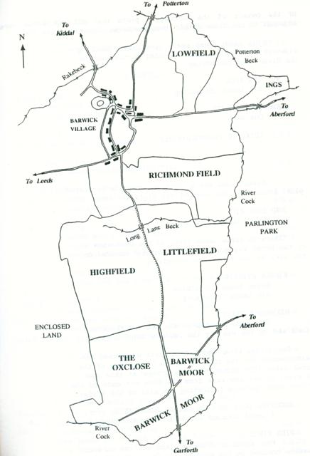
The Barwick Open Fields from John Flintoff's Map 1772

The document lists the various parts of the rector's land or 'glebe' but gives no details of any tenant farmers to whom the land was leased or the rents paid. The rector's land holdings are listed separately in the four open fields and their named flatts, and in the ings and pastures. The plots are listed below. The sizes of the plots are given in acres, roods and perches.

RICHMOND FIELD
a. r. p.
FLATTS. Six lands Bounded on the East by the River Cock. On the West by Richard Haist. On the North by Lord Bingley. On the South by Jackson. It contains 6 0 0


This is the form of the entries throughout the document. It shows that here at least one 'land' equals one acre in area, although later entries show that the acreage of a land is variable. There is no map that we have found that shows the exact position of the flatts or of the rector's 'lands' within them. The names of the owners of the surrounding plots are omitted in the list below for reasons of space except where they contain information that could show the position of the plots. It is clear from the names of the owners of the surrounding plots that all six lands were adjacent to one other rather than scattered throughout the flatt.

Six Lands 'Jump again (presumably meaning adjacent to) Jackson Croft' bounded on the east by the River Cock containing 6 0 0
HUD ING NOOK
Six lands containing 3 0 0
STONYFORD FLATT
One acre 1 2 0
TOTAL in RICHMOND FIELD 16 2 0
LITTLEFIELD
Seven lands and a 'but' (an irregularly-shaped plot) bounded on the west by the Highfield Hedge 3 2 0
HUD INGS HILL
Eight lands containing 4 0 0
"There is three lands lieth to the East side of the Broad Way going up the Stinting" bounded on the west by the Broad Way containing 2 1 0
MIDDLE STINTING
Seven lands containing 3 2 0
Six lands containing 3 0 0
DINBRIDGE FLATT
Six lands bounded on the east by the River Cock and on the West by the Oxclose 'Edge' containing 3 0 0
Note.The bridge after which this flatt was named has disappeared but the first Ordnance Survey map of the area dated 1859 shows 'Hunter's Bridge' at this spot. A right of way now runs from the farm and ends on the river bank, perhaps indicating the site of the bridge.
SHOOTING DOWN TO COCK CALLED SIDE PIECE
4 lands bounded on the east by the River Cock 1 0 0
SIDE PIECE
Four acres of 'Plowing' land and one acre of meadow bounded on the east by the River Cock 5 0 0
STONYFORD FLATT
2 acres bounded on the east by the River Cock 2 0 0
TOTAL FOR LITTLEFIELD 27 1 0
HIGHFIELD
SHAW HEAD
Two lands containing 1 2 0
Three acres and two roods 3 2 0
SHAW GAP
Four lands containing 2 2 0
BRIDGES CLOSE
Five lands containing 5 0 0
SYKE LANE
Two acres containing 2 0 0
Four acres containing 4 0 0
BARKER CLOSE
Two acres and a rood containing 2 1 0
Two roods containing 0 2 0
One land called three roods containing 0 3 0
BARKER CLOSE END
Four acres and one rood and two butts 4 3 0
PYE GARTH STYLE
One acre bounded on the south by the Road Way to Oxclose Gate containing 1 0 0
Two half acres bounded on the east by the 'Green Hill' facing Highfield Gate 1 0 0
TOTAL FOR HIGHFIELD 28 3 0
LOWFIELD
Six roods shooting down to Potterton Beck bounded on the north by the beck containing 1 2 0
One rood of land called Side Hill, the foot way to Potterton containing 0 1 0
Five lands bd. on the north by Potterton Beck 0 1 0
Five lands bd. on the north by Potterton Beck 0 2 20
One acre containing 1 0 0
Two acres of 'Plowing' land and one acre of 'Grassing' called Cryke, now enclosed 3 0 0
ASSBRIDGE BAULK
Two lands containing 0 3 0
TOTAL FOR LOWFIELD 8 1 0
"There is a great Flatt of Land called Desmesne belonging to Sir Bryan Cooke Bart. now inclosed in this field."
BARWICK INGS
MEADOW
Six days mowing bounded on the east and south by 'Potterton Liberty' containing 6 0 0
One day mowing containing 1 0 0
Note.The term 'Potterton Liberty' tells us about the status of Potterton within the manor. The term means that it is a privileged area with independence from many of the manorial duties. This no doubt derives from its situation in post-Conquest times when it was held by 'one knight's fee' (see 'The Barwicker' Nos. 25).
PASTURE & GLEBE INCLOSURE
PYE GARTH bounded on the north by 'the lane joining the Glebe' on the other side 3 1 20
SYKE CLOSE bounded on the north by the lane 3 1 17
HUD INGS bounded on the south by Littlefield 3 0 0
TOWN END CROFT bounded on the south by the lane 0 2 0
DOG PIT CLOSE bounded on the west by Long Lane 0 2 0
COPWELL SYKE CLOSE contains 0 3 20
TOTAL FOR BARWICK INGS, PASTURE AND GLEBE INCLOSURE 18 2 17
BARWICK MOOR
THE NORTH END OF BARWICK MOOR
Six leys bounded on the north by Littlefield 1 3 16
Six leys bounded on the north by Littlefield 1 2 36
LOWER BARWICK MOOR
Four butts containing 0 1 39
Two swaithes containing 0 0 6
EAST END OF BARWICK MOOR
Six leys bounded on the west by the Oxclose gate 3 0 16
Six leys bounded on the west by the Road Way to Garforth containing 1 2 25
WEST END OF BARWICK MOOR
Six parcels (four leys, two leys, five leys, two leys,five leys and eight swaithes) all bounded on the north by the Oxclose and containing in all 6 0 15
A corner bounded on the north by the Oxclose and on the west by Ellis Lane 0 0 23
TOTAL FOR BARWICK MOOR 15 1 8
"The said Barwick Moor was but Half Year Land, but is now inclosed and occupied by Sir Thomas Gascoigne "
Note.The term 'half year land' means that common grazing on the moor had been allowed for six months of the year. Barwick Moor was now enclosed and divided up into separate private grazing plots of various sizes called 'leys', 'butts' and 'swaithes'.
OXCLOSE OR NEW CLOSE SO CALLED
"The rector has 14 Beast Gates and a half in the said pasture. But now it is inclosed. Bounded on the east by the Road Way to Garforth and on the north by the Highfield." 17 1 30
Note. A beast gate was the right to graze one cow on the land. By what miracle the rector is allowed to graze half a cow is not explained. From the alternative name 'New Close' we can deduce that the process of enclosing what had previously been common grazing land had taken place comparatively recently.
MORWICK AND MOORSIDES
There is a large tract (of moor) upon Winmoor
All the Glebe belonging to the Rectory of Barwick 135 2 15
"The rector has some glebe in Barnbow for which the Lord of the Manor (Sir Thomas Gascoigne) pays yearly two pounds ten shillings. There is no certain place to judge where this land is."


The terrier clearly demonstrates that a small open field system was still operating in Barwick in 1764. However it is quite clear that the scope of the system was being constantly reduced by enclosures. The rector's 'lands' in the open fields are not scattered about in the flatts but are adjacent, forming compact blocks which could be enclosed without further land acquisitions. In addition to lands in the open fields the rector owned several plots that were called 'closes'.

The evidence that the major landowners were active in the enclosure process is clear from the enclosure of Barwick Moor and probably the Oxclose by the lord of the manor, Sir Thomas Gascoigne. The terrier tells us that another prominent landowner Sir Bryan Cooke Bart. had enclosed 'A large Flatt' in Lowfield. He had clearly acquired enough of the land there by purchase or exchange to take it out of the open field system. We must assume that he had the agreement and perhaps the encouragement of the lord of the manor. Despite these pressures, the open field system survived here until the Barwick Enclosure Award of 1804 (See 'The Barwicker' No.12).

Only a few field names used in the 1425 survey are found in this terrier. The others have vanished as some of the names used here will vanish after the Enclosure Award. Apart from the details of the rector's land holdings and the evidence for the open field system, the terrier describes some features of the landscape. What a picture is conjured up by the description of the long narrow lands 'shooting down' to the banks of the Cock Beck, always elevated here to the status of a 'river'. We read of the hedges surrounding the Oxclose and the open fields with their gates, here surely used as a term for a swinging barrier and not meaning a road, as in 'Kirkgate'. The terrier uses the terms 'road', 'way' and 'lane'.

The positions of Assbridge and Dinbridge are known but where is 'Bridges Close' in the Highfield? Is the name derived from a previous owner called 'Bridge' or does it refer to 'a bridge', perhaps over Long Lane Beck? Long Lane itself is mentioned and the 'Road Way to Garforth', but where is the 'Broad Way going up the Stinting'? Where are 'Syke Lane' and the east-west running 'Road Way to Oxclose Gate', both in the Highfield? Where is Ellis Lane? Where is 'Side Hill, the footway to Potterton'? Can we still see 'the Green Hill facing Highfield Gate'?

Reading the terrier gives one more reason for walking the local footpaths to see if it is still possible to discover these features of the past Barwick countryside.


ARTHUR BANTOFT


Back to the top
Back to the Main Historical Society page
Back to the Barwicker Contents page