This article is based on a talk and slide presentation
given to the Historical Society, by Mr S.A.Moorhouse, Deputy
County Archaeologist.
Whilst man and nature have combined to create a
wonderfully varied countryside, the majority of what we see
around us today is man-made. The better our knowledge of
the history and shaping of the local landscape and the more
fully can we hope to value and understand our rural heritage.
To this end the West Yorkshire Archaelogical Service exists
to provide comprehensive archaeological advice to local
authorities and members of the public, to excavate and
conserve monuments where appropriate, and to promote a wider
understanding of archaeology through publication of guide
books and newsheets, and the presentation of displays and
exhibitions.
Archaeological sites are continually being threatened by
development of various kinds, or are gradually lost as a
result of ploughing and erosion. Indeed, many sites were
ploughed out of existence by the Middle Ages, and the only
way that these can be detected is by aerial observations.
Aerial photography provides an effective means of
identifying and recording archaeological sites which, in many
cases, are no longer discernible at ground level. The
techniques used have been developed during the last fifty
years. The remains of former settlements, tracks, ditches
and enclosures are exposed by different kinds of marks.
There are "shadow" marks cast by ground irregularities, when
the sun is low in the sky, and "soil" marks which show on
the surface of a recently ploughed field. "Crop" marks show
as dark lines where the greater depth of humus in former
ditches, and other excavations, produces a stronger overlying
growth of darker green, which contrasts with the surrounding
crop. Other features of interest can be revealed when
ancient remains are covered by light snow or frost.
An examination of aerial photographs of the Barnbow
Carr area, to the south of Taylor Lane, reveals clear
evidence of an ancient enclosure, together with the outlines
of several banks and ditches which comprised a settlement
that once occupied the site. The crop marks are probably
pre-historic or Romano-British in origin. A "corrugated"
pattern of medieval ridge and furrow strips can be clearly
identified leading up to a headland (a wide baulk across the
end of the strips where the plough was turned), which is
clear evidence of a former medieval open field system.
The plough ridge (or selion) was the basic agricultural
unit of land holding, the centre of the furrow being the
boundary of the strip. The ridges were formed over a long
period by tillers who used a heavy mould-board plough. To
maintain and develop the ridge the ploughman would cut his
first furrow just to the left of the ridge centre line, the
plough tipping the soil to the right. On his return, the
soil is again tipped to the right to lie against the original
turf in the form of an inverted "V". Each succeeding furrow
is then ploughed a little further to the left of the previous
one, both up and down the strip, so that when the ridge is
completely ploughed all the turf strips incline inwards.
In time, this method of ploughing produces marked
ridges, which assisted the drainage of flat, low-lying
ground, while furrows developed between the ridges. The
furrows consist of darker humid material which shows up as
dark lines on the aerial photographs.
A medieval plough team was quite long comprising up to
four pairs of oxen on heavy ground, in addition to the man
and plough. The ploughman would begin turning his team
before the leading beast reached the end of the plough ridge,
with the leading pair being swung to the left; the turn being
completed on the headrow. Towards the end of the return
trip, the team was again swung to the left, and the general
result was a plough ridge that was not dead straight, but
had the distinctive alignment of a backward or reverse "s".
Parlington Hollins lie to the east of the Garforth road,
near the Golf Club, and aerial photographs of this land
between the road and wooded area, show a number of circular bell-pit mounds, which are superimposed over earlier medieval
ridge and furrow strips that disappear into the woodland.
The bell-pits, and surrounding mounds of shale, are the
remains of old coal workings, where vertical shafts have
been dug down to the underlying coal seams. The bottom of
the shaft was widened out as coal was extracted, giving the
cross section a bell-shaped appearance, hence the name.
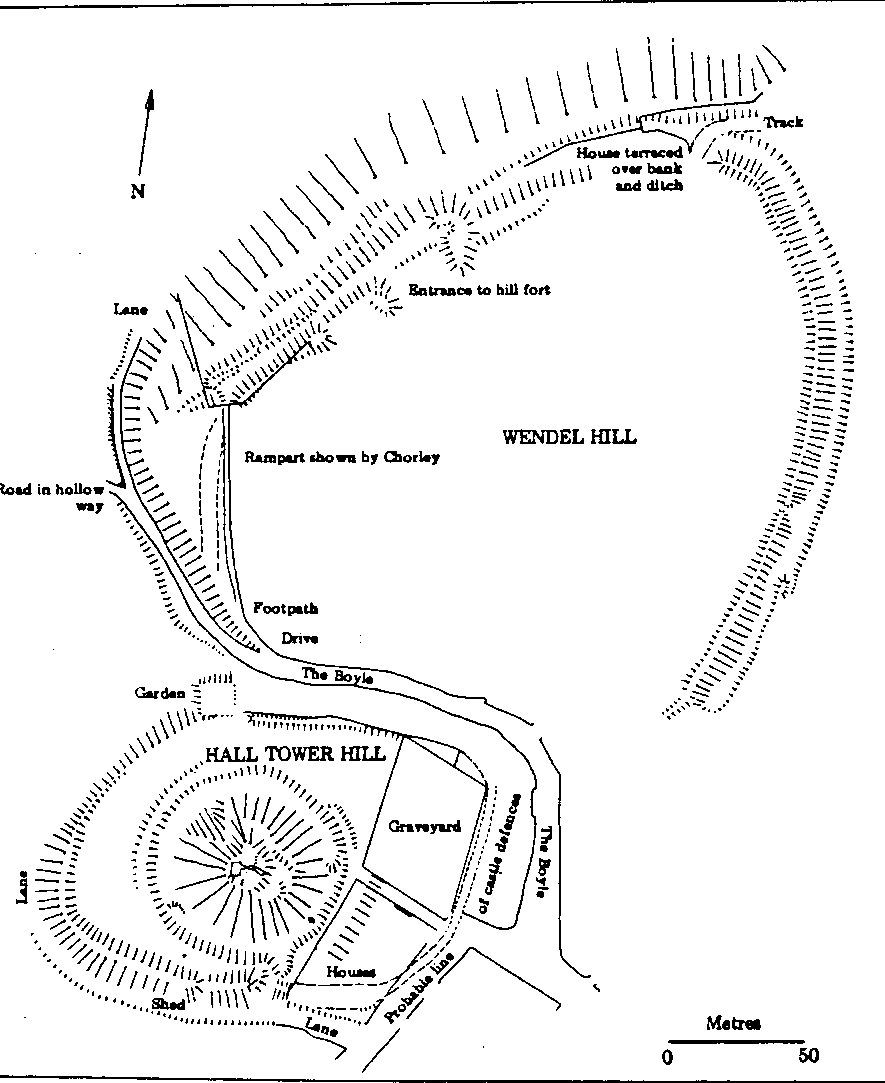
Barwick was at one time the centre of a prehistoric
tribe. The only evidence that now remains is Wendel Hill,
which is a multi-vallate or multi-ditched, Iron Age fort.
This is essentially a prehistoric defended enclosure that was
modified in the Middle Ages (and possibly in Saxon times) by
the insertion of a matte, a mound with a stone tower on
top. Normally the motte stands to one side of the bailey,
but at Barwick the mound is centrally placed, with the motte
and bailey occupying only part of the original fort.
The 6.1 hectare site of the earthworks incorporates two
semi-circular enclosures, one to the south on Tower Hill. and
the other to the north on Wendel Hill. The size and
character of the original fort has been obscured by the
subsequent use of the site as a medieval administrative
centre. The extensive remains of a bank and ditch on the
northern and western sides of the earth works provide the
best preserved evidence of earlier Iron Age occupation.
The fort at Barwick is one of three that are known at
present in West Yorkshire, the others being at Castle Hill
(Almondbury) and at South Kirkby (near Hemsworth). They
did not exist in isolation, but were an integral part of the
territories populated by Iron Age farmers whose settlements
are increasingly being discovered by aerial photography.
The two largest estates within the county during the
Middle Ages were the Manor of Wakefield and the Honour of
Pontefract, which were divided for administration purposes
into smaller units. Barwick, which at Domesday in 1086
belonged to the royal Manor of Kippax. became the
administrative centre of the northern part of the Honour of
Pontefract, and replaced Kippax in order of status.
The Earthworks at Barwick (after H.S.Chorley).
(Reproduced by permission of Prof. K.Branlgan, Sheff. Univ.).
The restructuring of boundaries in the Barwick area
during the 13th. century probably explains the use during the
Middle Ages of the site of the former Iron Age fort. The
enhanced status of Barwick did not last long and by the
1340's the principal residence and role of administrative
centre north of Pontefract had transferred to Rothwell.
This latest shift in Barwick's role is reflected in the
content of the remaining earthworks. There are no stone
buildings and apparently no stone defensive works, although
excavation of the motte about the turn of the century
revealed a length of stone walling of unknown date.
The conversion to the use of stone as a building material
took place during the 13th. century and the absence of
stone in the earth works at Barwick is an indication that its
importance as an administrative centre did not develop.
Also there is evidence that in the 14th. century, the herbage
of the ditch surrounding the earthworks was valued for
grazing rights; circumstances that would not have applied
had the property been of recognised status.
Because of its importance, Hall Tower Hill/Wendel Hill
is scheduled as an ancient monument protected under the
Ancient Monuments Areas Act of 1979. It is considered that
no plans have yet been produced that do full justice to the
earthworks, and a comprehensive survey would be one of the
first requirements towards achieving a better understanding
of the development of these historic remains. A full
archaeological exploration of the site would be a very costly
operation, especially as every six months spent on
excavation requires a further 18 months to report on the
findings.
Techniques used in archaeology have, however, advanced
significantly in the last thirty years and will eventually
provide a much wider range of information than at present;
possibly without the need to excavate, which is a
destructive operation and best left to rescue archaeology.
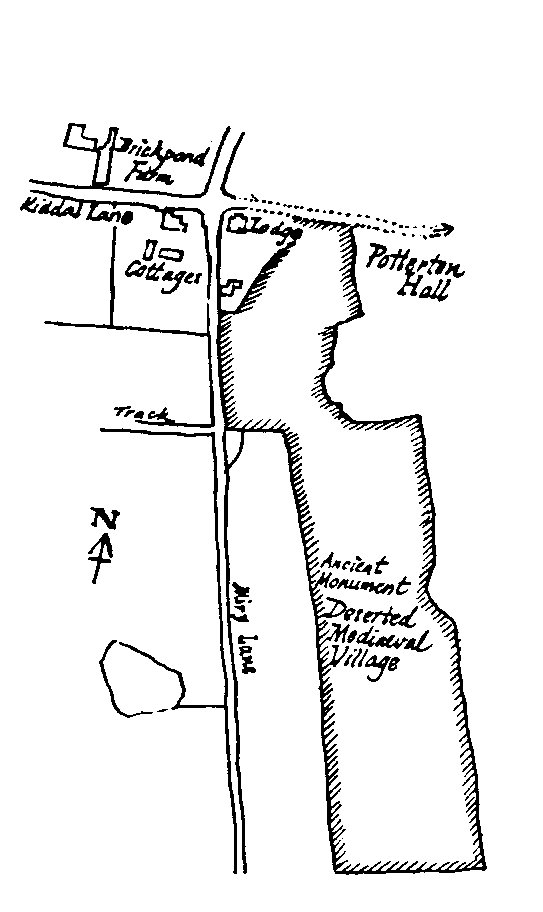
Potterton is the site of a deserted medieval village. a
more extensive settlement than exists at present. The
former Village was located on a stream to the south of
Potterton Hall and some of the ground features are
remarkably well preserved. The earthworks of a small number
of probable medieval tenements still survive, bounded by a
bank and hollow way. Aerial photographs of the area show
the remnants of a medieval field system on land to the west
and south of the former village; with very distinctive curving, reverse "s" shaped ridge
and furrow plough strips. Potterton was referred to in Domesday Book of 1086, the
derivation of the name being Potter-tun the settlement of the potter.
The potting would have involved a whole community of potters,
although where the activity took place is not known. It was unlikely to
have been located within the abandoned medieval tenements, as no potting
debris has been found in this area, but there is 1ittle doubt that the site is somewhere in the vicinity of Potterton Hall.
The date and reason for the abandonment of this part of
Potterton have not been established. The remains of a later,
fifteenth century pottery kiln were discovered at Potterton Grange Farm some years ago and this will be the subject of a future article.
Barwick was clearly a planned settlement, with the medieval core of the village comprising
the front street and back lane, and a regular series of parallel land plots (or tofts)
running back from the main frontages. (See the map of 1772 in "The Barwicker" No.3). By
examining a series of relatively recent maps of, say, Thomas Jeffries' 1770's maps
onwards, it should be possible to work out the development of Barwick from the medieval period right through to the
present day and the Historical Society hopes further to pursue this absorbing subject.