A Place Called Barwick
Back to the Main Historical Society page
Back to the Barwicker Contents page
A Place Called Barwick
Barwicker No 6
July 1987
"The Barwicker" is the name of this journal and also of a
person born and bred in Barwick. But Barwick what? Barwick village?
Barwick parish? Barwick manor or township or ward? Each place-name
points to some aspect of Barwick history much of which has yet to
be unravelled.
The easiest term to define is the village, that collection of
houses and businesses which has grown up around Barwick church. The
precise details of its origin are lost, but one can speculate on the
reasons for its position. It is a well-drained site, free from
flooding, with a good water supply from wells. Being on higher
ground, it would be more easily defended than the immediate
surroundings. Security would also be increased by living close
together rather than in scattered dwellings, and this is in keeping
with man's gregarious nature.
Early plans of Barwick show that it had some features of what
is called a linear village. The dwellings on the west side of Main
street were built on narrow plots running back from the street.
These were bounded by Back Lane, now Elmwood Lane. Extending beyond
this were longer strips, called crofts, which could be used for
grazing a cow or horse. A similar system of plots occurs on the
north side of The Boyle and The Cross with the crofts running over
Wendel Hill, parallel to Potterton Lane.
Barwick manor goes back to Saxon times. The Domesday survey of
1086 linked Barwick with Kippax and Ledston, together with several
other villages in the district, as land held by Edwin, Earl of
Mercia, before the Conquest.
In Norman times, there appears to have been some fragmentation
into smaller units. The boundaries of the manor of Barwick cannot
be drawn with accuracy, but as it was enclosed by the manors of
Scholes, Shippen, Garforth, Parlington , Potterton, Kiddal and
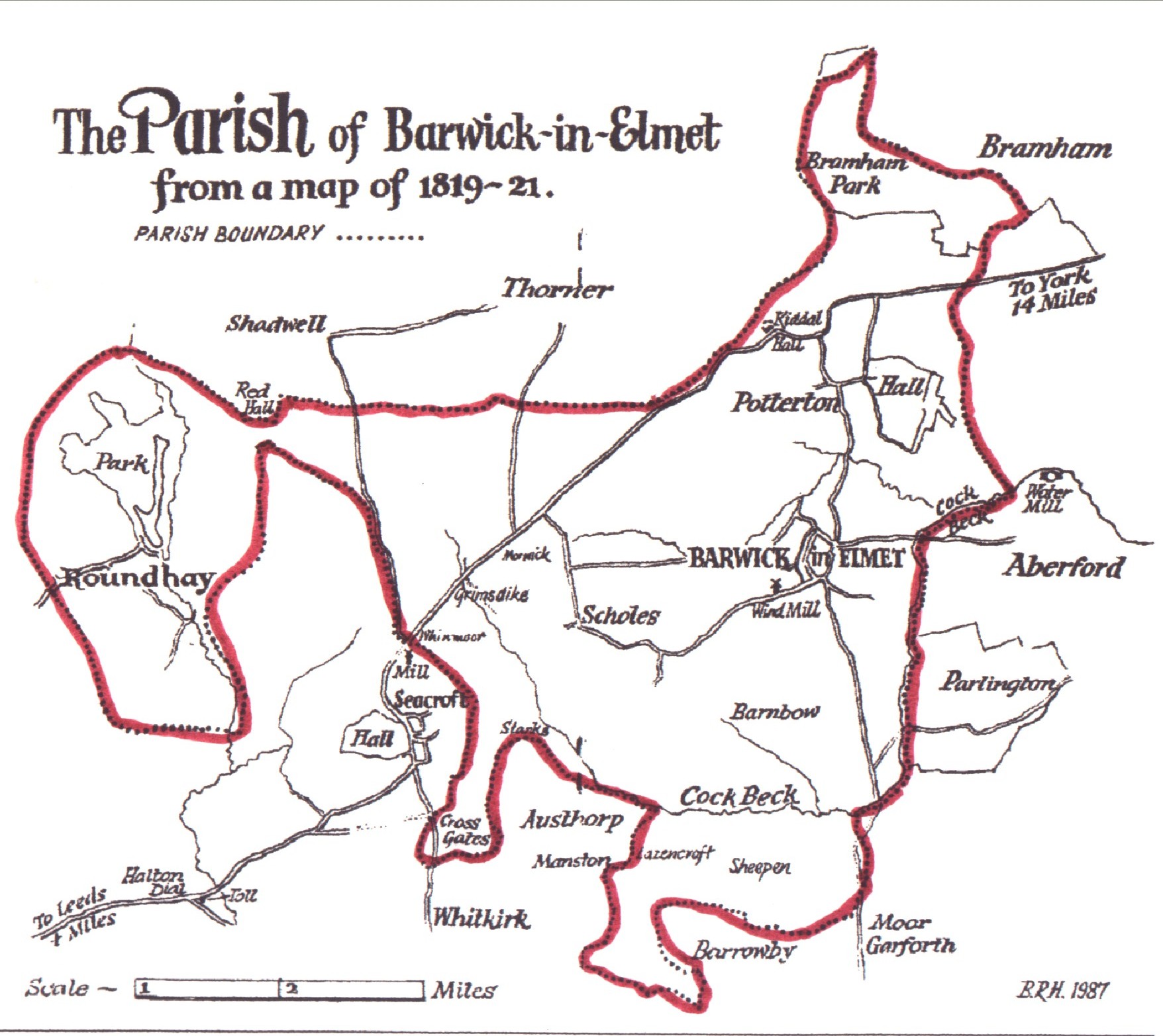
Thorner, its approximate limits can be imagined, (see map below).
Colman's History of Barwick-in-Elmet includes some details of
Barwick and neighbouring manors, but knowledge of what was a
constantly changing situation is scanty. There is some source
material in the Gascoigne Papers in Leeds District Archives. This
requires researching so that a definitive history of the manor can
be written.
The manor was concerned with economic, administrative and
military affairs. Religious matters were organised within the
parish, which was in the charge of one priest or parson. Parishes
are thought to have originated when lords of manors built churches
for themselves and their tenants, and introduced a system of tithes
to support the incumbents. Churchwardens were appointed to
administer parish affairs. Parish boundaries were determined by
tr.ose of the manor or several manors. The original Barwick parish
included Barwick itself, the hamlets of Barnbow, Kiddal, Potterton,
Scholes, Grimsdike, Stanks, Whinmoor, Morwick, Crossgates and part
of Manston, and also surprisingly Roundhay. This situation
remained until the nineteenth century.
As the importance of the manor declined with the end of its
military aspect, civil administration passed into the hands of the
parish. Where parishes were large, especially in the north, they
were divided into several townships which carried out these civil
functions. Barwick parish was divided into two townships, namely
Roundhay and the remainder of the parish, which made up Barwick
township. An important township official was the constable,
responsible for enforcing the law. Overseers of the poor were
elected by the townships to collect the poor rate and to use it to
relieve the poor.
The parish and township officials were elected and other
business was conducted at gatherings of ratepayers called vestry
meetings. Barwick has a fine collection of parish and township
records, including those of the churchwardens, overseers, constables
and surveyors of the highways.
The independence from each other of the two townships was
demonstrated when Roundhay became, in 1807, a founder member of the
Great Preston Gilbert Union or Incorporation, which administered
Poor Law affairs. Barwick township waited until 1822, when the
Barwick-in-Elmet Gilbert Incorporation, which eventually comprised
42 townships, was formed with its workhouse in Rakehill Road. The
Incorporation was dissolved in 1869 and Barwick township was added
to the Tadcaster poor Law union. This formed the basis of the
Tadcaster Rural District Council established in 1894.
In this year, local government by vestry meeting was replaced
by the elected Barwick Parish Council. Elections were conducted in
three wards, those of Barwick, Scholes and Crossgates adding another
geographic unit to the Barwick collection. In 1912, Crossgates was
taken into the City of Leeds. At the local government
reorganisation of 1974, the Tadcaster Rural District Council was
abolished, and Barwick and Scholes became part of the Leeds
Metropolitan District.
Changes occurred also in Barwick parish. In 1826, St. John's
Church in Roundhay was consecrated. It was not assigned a district,
and its separation from Barwick was a gradual one. The last act
appears to have been the institution of the incumbent for the first
time as Vicar of Roundhay in 1925.
In 1840, the Church of St. James the Great, Manston, was built
at Rector Bathurst's expense to serve the western part of the
parish. In 1856, Manston became a separate parish.
St. Philip's Church in Scholes was built in 1875 and was
replaced by a modern construction in 1966. Scholes remains within
the present parish of Barwick-in-Elmet.
What, then, is Barwick and what is a Barwicker?
For the historian, what we mean by Barwick is determined by the
source of information available to us, whether it refers to Barwick
village, manor, parish O~ township. And a Barwicker? May we
modestly suggest that an essential ingredient is that he or she
reads "The Barwicker".
Arthur Bantoft
Back to the top
Back to the Main Historical Society page
Back to the Barwicker Contents page